I, on the other hand, have not finished a race longer than a 5k, get majorly bored when running anything past 4 mi, am ridiculously slow, and cannot seem to finish training for anything. The result of the three times I trained for a marathon were thus: two ended in injury (but only one worth quitting for) and one ended from extreme lack of motivation (see running past 4 mi comment). I resolved that I am just not running material.
I love to run, don't get me wrong, but clearly I was not meant to be a "runner."
You know the type. They have long sleek legs (ahem Blonde and Redhead), they talk about shin splints, IT bands and runners knee, they track mileage and heart rates like fat people count calories.
They are all part of this exclusive club of endurance and stamina and willpower.
I am not one of them.
But then I discovered trail running.
Following a particularly rough emotional patch of life, I found myself going on a solo "hike." That environment, along with the aggravation I felt over my job/calling/boy/other personal issues (take your pick) led me to let out some frustration by just pushing my body to the max, running through the trees, sprinting over streams, and winding my way through obstacles. What a rush! It's like running on crack. Your body is soo overwhelmed with conquering the next obstacle you don't recognize that you are breathing heavy or your legs are sore or your IPOD has replayed the same song three times.
IT'S AMAZING. Just sayin', check it out.
Here are some of my favorite Trail runs around the Salt Lake Valley:
City Creek Canyon
West Side Trail:
Take the Bonneville Blvd Street to the entrance of City Creek Canyon. The trailhead is on the west side of the road to the canyon.
Distance:10 mi round trip (I have only gone 6-3 up and 3 down, going to conquer the rest one of these days)
Trail: Singletrack
Difficulty: Medium to Mild, Mild upgrade the first 3 mi, downhill you can cruise
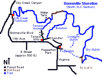
Bonneville Shoreline Trail
Trail Entrance: Take the Bonneville Blvd Street to the entrance of City Creek Canyon. The trailhead is on the east side of the road to the canyon.
Distance: However long your heart desires
Trail: Singletrack to dirt road
Difficulty: Depends on the area. The beginning of the City Creek entrance is a brutal 3 mi 650 vertical feet climb with a total elevation gain of 1250 ft singletrack that you share with mountain bikers. Beware. Other areas are much less brutal but I love going up and then coming back down the climb full speed. The Bobsled portion is a great descent along with the Dry Gulch. I have done all three as separate runs.
Map:
Note: The trail continues all the way to This is The Place State Park but I haven't done that section of it.
Dog Lake Trail
Big Cottonwood Canyon:
9.1 miles up Big Cottonwood Canyon is the Mill D Trailhead. Take the Dog Lake Trailhead out of the North Parking Lot. Visit here for more directions.
Distance:5 mi round trip. Uphill then downhill
Trail: Singletrack
Difficulty: Medium with a steeper elevation change. Uphill out, downhill back. More of a hike but I still ran a lot of the uphill.
Optional: Northeast is a trail to Little Water Peak that is only a 1/2 mi more. I took it last time and loved it.
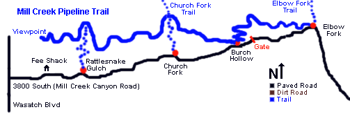
Millcreek Pipeline Trail
Millcreek Canyon:
Take I-215 getting off on 33rd South head east. Take a right onto Foothill Blvd and a left onto 3800 S. heading east into the canyon. Many entrances to Trailhead, I prefer Burch Hollow which is 3.5 mi past the fee station.
Distance:14ish mi round trip. I head west from Burch Hollow for as long as I feel and then go back. Also I have run up towards Elbow Fork and back for a different run.
Trail: Singletrack
Note: Popular with mountain bikers
Mueller Park Canyon:
Take Bountiful exit 2600 S. and head east. Take a right on 1800 S. for 3-4 mi. Trailhead is just before the fee entrance to Mueller Park.
Distance: 6-8 mi round trip. Uphill then downhill
Trail: Singletrack
Difficulty: Medium to difficult beginning with a constant elevation increase. First 1.6 miles the thoughest then it levels out a bit until the last .25 mi to the rock. Uphill out, downhill back. More of a hike for the uphill part but I still ran the majority of it. The return is a REALLY fun downhill breeze of 3-4 mi.
Optional: Keep going for a long run that loops around and spits you out of North Canyon...
Note: Way busy on weekends, week day mornings it is nice and quiet. Popular with mountain bikers
Have any favorite trails to share?

.jpg)


No comments:
Post a Comment